In a Nutshell: The Korean Demilitarized Zone (DMZ) splits the Korean peninsular in half creating a buffer zone between North Korea and South Korea. It’s the most militarized border on earth. Ever wonder what it’s like to visit the DMZ? Better yet, visit the DMZ from the North Korean side? Let me give you a virtual tour. Beginning in Pyongyang due south to Panmunjom, here’s what you can expect on a trip to the world’s most dangerous border.
Barbed wire line all fences, tank traps enclose us and the remainder is a laden, active minefield. One million soldiers stand guard; overseeing from outposts – gazing across the border into forbidden lands once unified and the eyes of South Korean military. The peace treaty was never signed, and the war between the North and South of Korea still rages over 60 years on. At least technically, anyway – and the Demilitarized Zone (DMZ); the border between two countries now worlds apart serves as the best reminder. Here, in the eye of the storm at Panmunjom…a one metre misstep would likely see you shot or an extensive visit to a ‘re-education’ camp.
It seems dramatic, but that is the reality. There may not be bullets flying overhead or active servicemen crossing the border but tensions are high. Since the Korean Armistice Agreement was penned in 1953 there has been over 1000 ‘fracases’ and a further approximate 50 serious incidents here, including one recently where a young North Korean soldier defected into South Korean hands across this very border to the east.
I was pretty excited to see what it was like for myself. Visiting from the exclusivity of the North Korean side was shrouded in a mystery that fascinated me. I’d read a lot about the DMZ history and it’s ongoing volatility to danger – quite the juxtaposition from the characterised Disneyland-like novelty from the South Korean side.
It’ll be interesting to see how this differs in the North. If at all. I just couldn’t imagine the DPRK approaching it in a similarly playful manner.
My initial expectations? Well — serious faces and strict rules under stringent government chaperone, where my actions will be monitored and judged at all times. Of course. Oh and military checkpoints. Lots of them. Apparently though, the DMZ is the only place in North Korea I won’t be shot for photographing a soldier. Which is cool. We’ll see how that goes.
Getting to the DMZ – Leaving Pyongyang
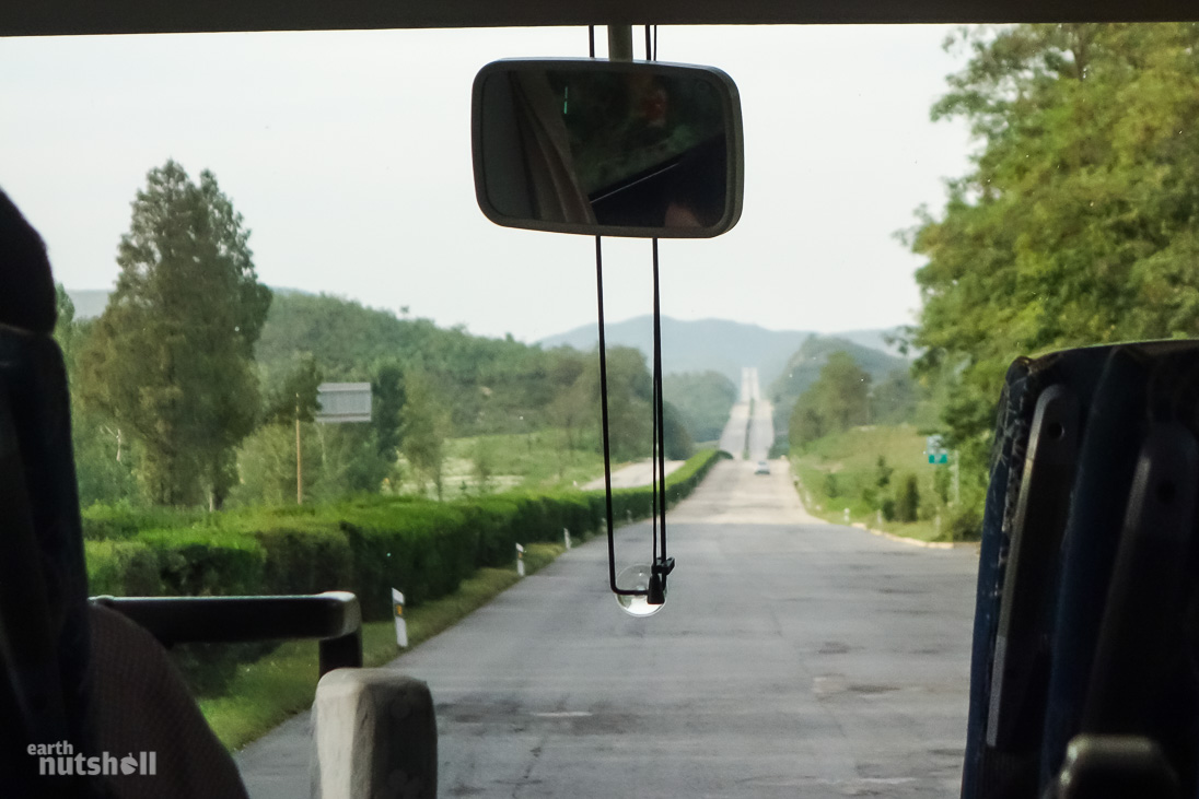
Overnight was in Pyongyang in the fabled Yanggakdo Hotel, towering alone on it’s segregated island in the Taedong River. Away from reality. This meant an 8:15am departure marked the beginning of our three hour bus trip south – to the most dangerous border on earth.
Pyongyang is dead quiet, only the sounds of factory industry and industrial boats break the silence. The Yanggakdo Hotel lobby is populated in time for tour departures, and the receptionists keenly await us to clear out – denoting one thing: time to switch off power to the 47 floor hotel until evening. Power shortage in Pyongyang is transparent.
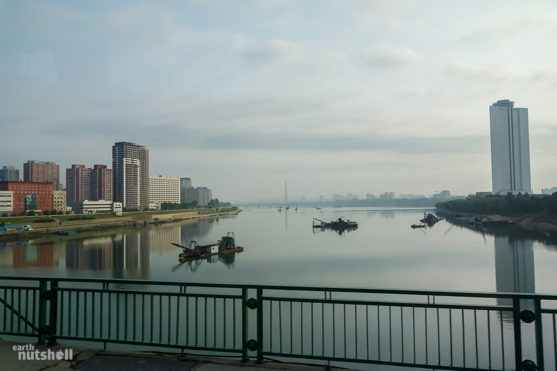
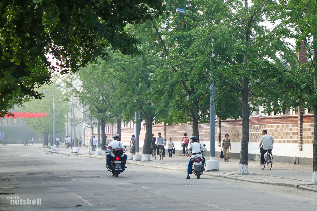
Life goes on for Pyongyangladites as our bus traverses through. The working class pack bus shelters in 50 metre long snake lines and people sparsely roam the city by foot or cycle styled in monotone dark clothing. Pop culture traffic ladies – beautiful; spotless and dressed in all white direct what little traffic there is left. The smog of factories fill the air above lonely soviet apartment blocks and the pain of day-long hard manual labour can be made out in the distance if you listen hard enough – or maybe that was just me filling in the blanks.
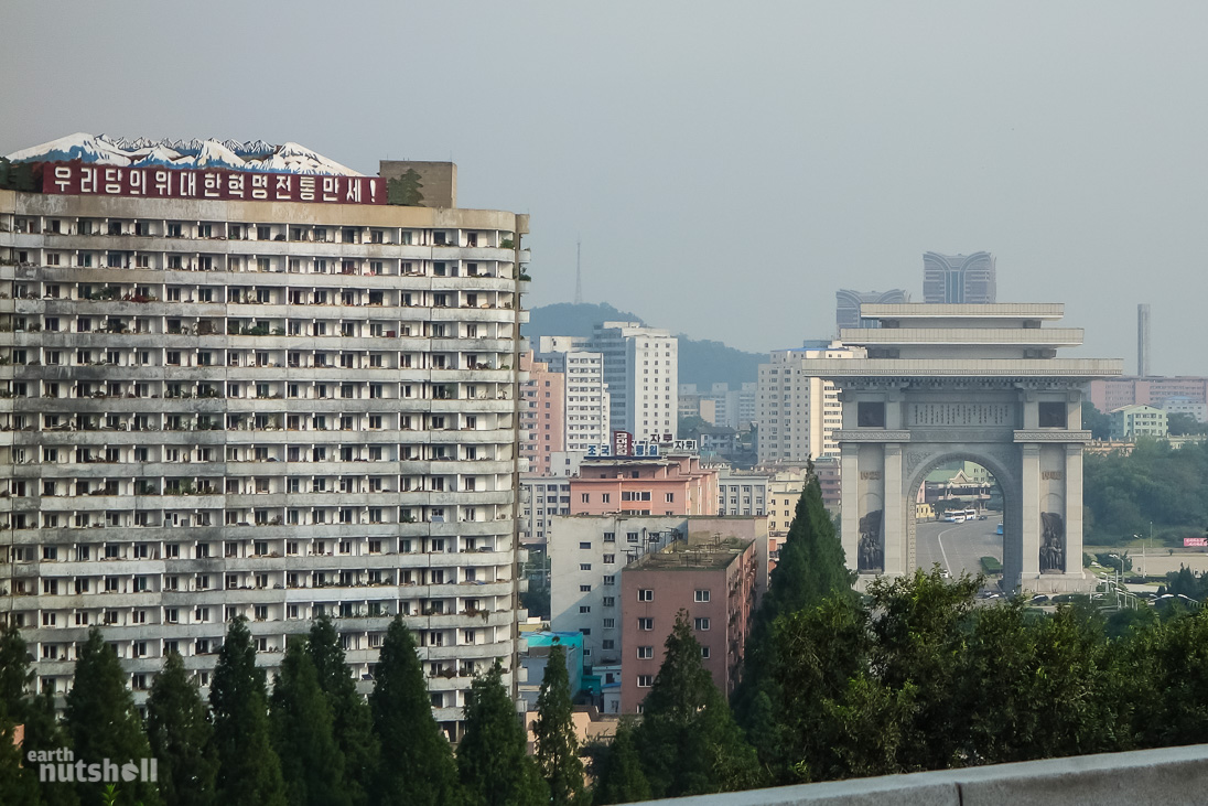
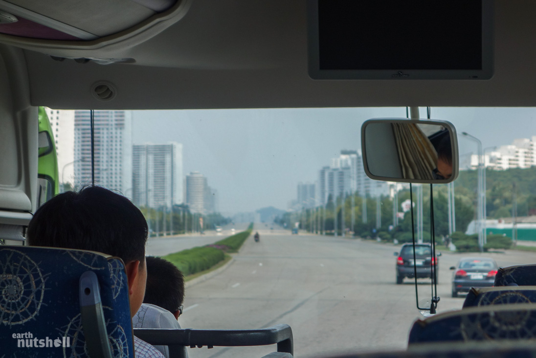
On the outskirts of Pyongyang we cross underneath the oddly ironic, yet marvellous Arch of Reunification forming a humbling southern gateway to the city. The city ends here. Instantly. It’s akin to breaking through a bubble – a distinct cut off between privilege and poverty. What follows is seemingly a desolate rural no-mans land without end in sight. This is the Pyongyang-Kaesong Motorway.
It seems that way because well…there actually is nothing – and you have crossed into no-mans land. Unofficially known as the Reunification Highway; it’s a six lane controlled-access link between Pyongyang and Kaesong (through Sariwon), and hence to the DMZ. There is no traffic to speak of. However, there’s no shortage of military checkpoints. Creepily, signs on the highway specify distances to Seoul, South Korea rather than the DMZ. Interesting. A remnant of a time since passed, or reunification misdirection for the tourists shuttled down here? I am unsure.
A trip to the DMZ is mandatory to most Pyongyang tourism itineraries. The reunification highway appears regularly in photographs by foreign media, you may have seen it before. It’s the only ‘rural’ government sanctioned road traversed by foreign journalists given permission to film in North Korea, after a six-year long waiting list. They aren’t allowed to film out the window.
It’s interesting, because on further investigation…you realise this road is almost completely point to point; Pyongyang to the DMZ. It conveniently skips villages, towns and farmland that may paint a slightly different picture of the DPRK.
Although rough, pot-holed and unmaintained – true to all North Korean roads outside Pyongyang, this motorway was in far better condition than most.
However, it’s still cripplingly lonely.
North Korean Countryside
It’s about 45 minutes into the drive before I come across well…anything.
A middle-aged man dressed in a silver suit jacket and pants in the blistering heat, bent over heaving a cart up a hill containing a large, live pig. Where he came from? Don’t know. Where was he going? Who knows. The pig looked fairly proud of itself though.
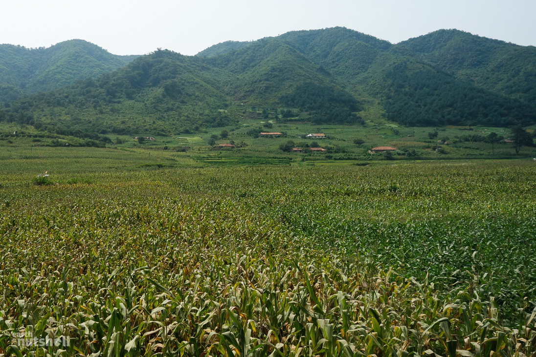
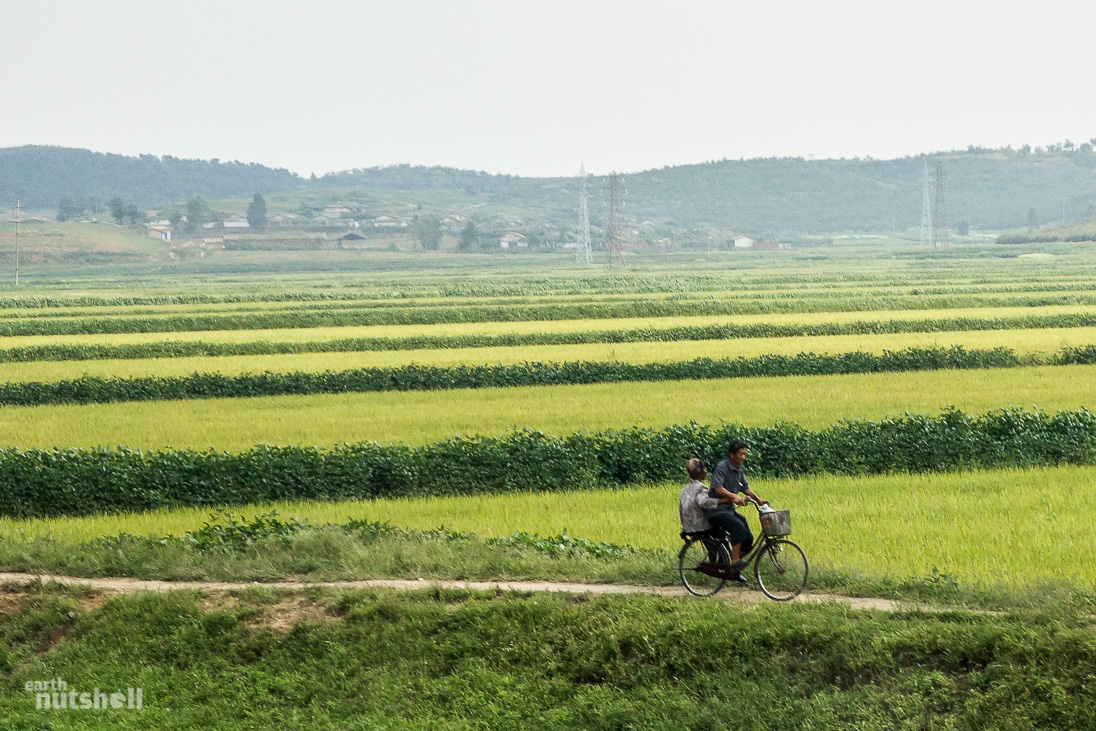
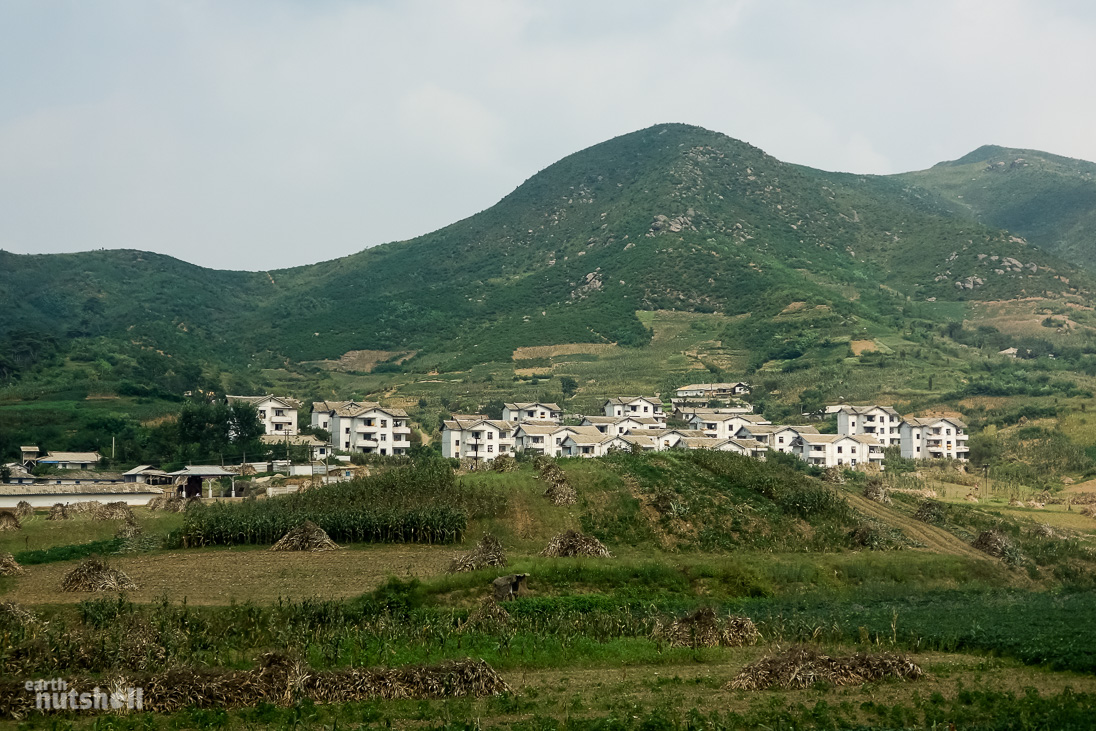
Activity increased as we descended further down south-west past Sariwon (which we visited in days following). Off-shooting villages became visible from the highway finally breathing some life into the barren countryside, yet accessible only by walking track. People wander the roadside alone on either foot or bicycle – sometimes tens of kilometres from the nearest inhabited community. I can only assume as a means to reach crops or villages with supplies. I spotted sacks of corn, bundles of sticks and leaves, sand, livestock and fruit baskets. Supplies are limited and act as the primary currency between North Korea’s impoverished. Similarities between less fortunate South-East Asian countries such as Laos cannot be dismissed.
I witnessed many poor souls pushing broken down motorcycles for miles too. Tough life.
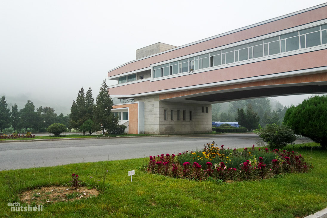
Halfway passes and we take a break at what the guides and most foreigners know as the Tea House (Sohung Rest House). For those readers familiar with the Vice documentary on North Korea, you may recognise it. It’s the location of the ‘Tea Lady’ segment, which I may add was vastly exaggerated on their part as a ghost town. In reality, Sohung Rest House sees regular visitors – it’s the only sanctioned stop between Pyongyang and the DMZ. Nonetheless, it’s a cool feeling to be in such a secluded yet recognisable place.
After enjoying some tea poured by enthusiastic ladies pleased to handle foreign currency, replenishing soft drink supplies and dry-reaching from the frankly disgusting toilets that lacked ventilation (I’ll save you the descriptive writing) we were back on our way down the deserted highway.
No photos were allowed from this point onwards until the DMZ.
This was strictly enforced. We were briefed that today wasn’t one for sneaky snaps out the window. Upon leaving Pyongyang I saw trains hidden by tall barriers – above which the upper half of military tanks were clearly visible. The guides spotted this too and as we passed; all guides turned to watch us like hawks to ensure stealth photos weren’t taken.
It’s no joke. It’s their heads on the chopping block if we don’t abide by the rules. The guides in North Korea are essentially an extension of your own responsibility. They take the fall for minor crimes on your behalf.
Military checkpoints began to appear in rapid succession. Four leading up to the city of Kaesong about 20 minutes apart. This was before we even arrived into the vicinity of the DMZ itself.
Good grief, what is it going to be like once we get there?
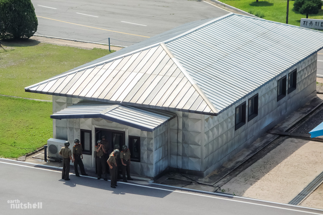
Each checkpoint gated off the road; splashing Korean signage widely enforcing a stop. They were a simple, yet unsettling process involving the driver passing across papers to an AK47 toting KPA (Korean People’s Army) soldier dressed in military olive green get-up, complete with peak cap and a whole lot of attitude. Our role was to sit in deathly silence, look ahead on our best behaviour and ensure anything with a lens quickly became invisible. Unless of course, a bus shakedown by the DPRK military was on your bucket list. I’d rather not. At least not now.
All things considered, these checkpoints are a slight inconvenience at most. Yet they are an intimidating process – but I think that is the point.
Broken down vehicles are common in North Korea. Really common. Beyond Pyongyang you can expect to see old trucks, cars and 1920’s antique farming equipment lining the roadsides. Each harbouring pairs of legs underneath as all occupants try and fix it at once. Today we pass such a victim – a Chinese KITC tourist minivan joining us for our timeslot at the DMZ. They waved us down and five minutes later our bus was back on it’s way joined by eight new occupants.
Not sure about the minivan driver. He stayed behind. Likely discussing terms of contract on a call to his insurance company…I bet.
Reaching Kaesong
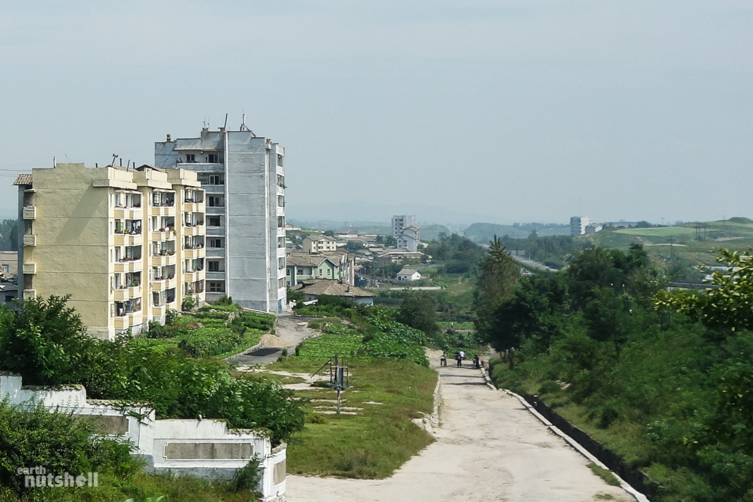
Not long after, we reach Kaesong – just a stone throw away from our DMZ destination of Panmunjom. We stay here in Kaesong accommodation tonight, sleeping on floor mats in traditional historical Korean dwellings.
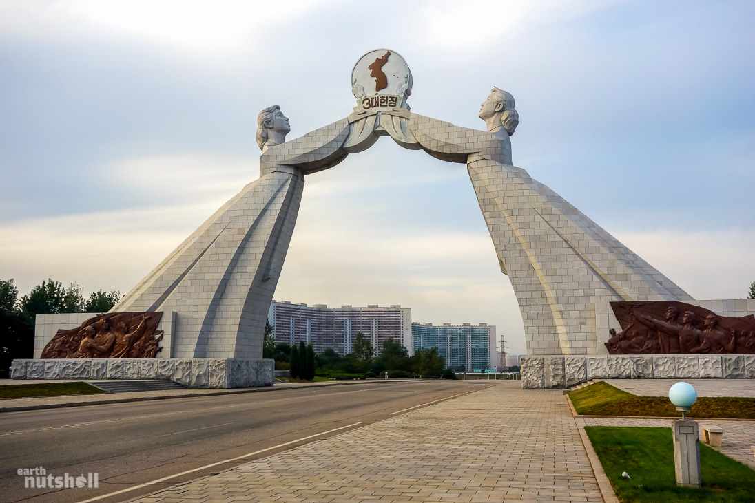
Due to it’s proximity to South Korea, Kaesong provides an interesting role in economics between the two nations including the morally questionable Kaesong Industrial Region (ROK companies employ DPRK labour for a pittance on DPRK soil). As we pass through, the guide points out Kaesong train station. The tracks lead directly through the DMZ to Dorasan train station, Seoul, South Korea. Forgotten and overgrown, it’s been since abandoned due to political conflicts in 2008.
These tracks represent a literal link between long lost relatives segregated across this tiny border. It’s hard to stomach it’s existence right in front of my eyes, contrasting the impossibility of reuniting those families just two hours apart. That thin border becomes figuratively wide when one million rifles stand between.
The DMZ Landing Area
We are again sternly reminded “no photos, no photos!” as we enter the preliminary area of the DMZ. With a keen eye, the towering flag poles of both North and South Korea can be seen in the distance less than four kilometres apart- the width of the DMZ splitting each nation.
We embrace yet another (and final, yay!) checkpoint, bringing it to a grand total of seven from Pyongyang to DMZ, not bad.
In a sudden and shocking realisation, I acknowledge that these checkpoints are not just here for foreigners.
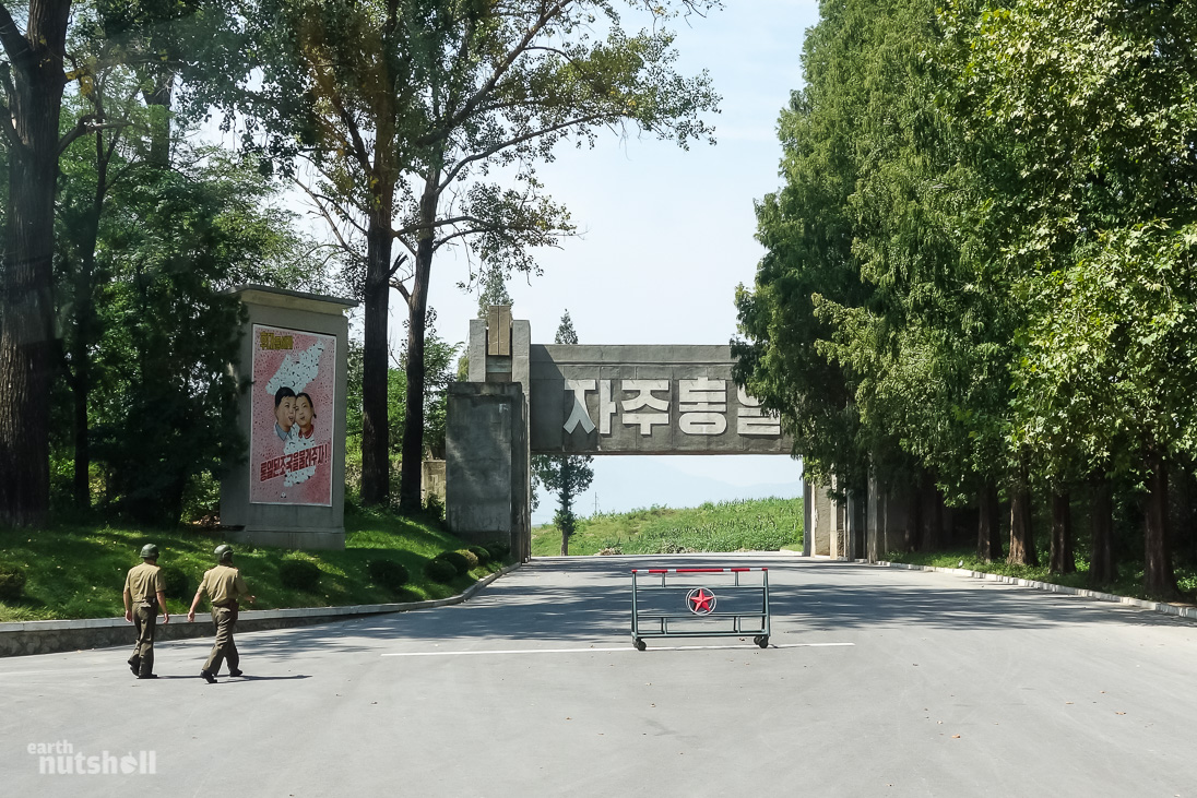
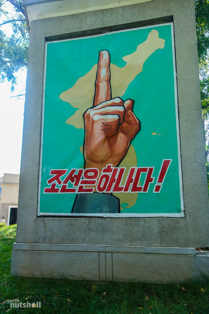
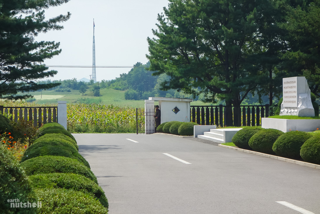
We soon come to a halt at the suitably soviet communistic looking gate pictured centre below, greeted by a mural featuring a large pointed finger subset by the slogan “Korea is One!”. My Korean is limited, it could have represented a player being given out at Lords Cricket Ground for all I was aware. I can’t unsee it.
My first thought? I guess it’s a technicality and a minor detail I won’t get hung up on…but we were standing aside a 4km wide, 250km long minefield purely designed to keep the North and South away from each other. Maybe I’m cynical, but Korea seems everything but ‘One’ to me in this moment.
Oh well, keep your glasses half full.
Now that we are here, there are three sections of the DMZ which I want to make clear…mainly because they confused me initially. I might not be the only one!
There is the Demilitarized Zone (DMZ) itself – this spans the entirety of the border; sea to sea, existing as a 4km wide buffer between both Koreas.
Centred to this DMZ buffer zone is the Military Demarcation Line (MDL). This is the actual political border. Overstepping this line is not a place to show your passive aggressive push for reunification – you’ll be shot. The MDL line is not accessible at many places a long the DMZ due to minefield on both sides. A North Korean citizen that would like to defect to South Korea would have to gain access to the MDL. It’s incredibly difficult and dangerous.
Today we are visiting the MDL through a special accessible section of the DMZ known as the Joint Security Area (JSA). It’s located to the west in the (now uninhabited) village of Panmunjom I’m currently standing nearby. What makes the JSA so special is that it’s the only area where the North and South come so face to face they could legally kiss.
Which they definitely don’t.
I’m progressive, I’m all for it! But that hurdle may not be a priority right now for some reason.
Anyway, in this staging area of our arrival we have to ditch the bus. It’s searched with a fine tooth comb and cleared for entry, in the meantime we are taken to get ‘registered’. Conveniently, the room we are to wait doubles as a souvenir hustle – ‘Panmun Souvenir Shop’ (soliciting tourists is a universal language, folks). Not usually a sucker for souvenirs, I’m in North-bloody-Korea and I helped myself to some ginseng jelly, some propaganda stamps and a replica Workers Party of Korea cap. Among other things…
Kim Jong Un may be eating extra lobster tail this week thanks to that 10 euros.
As I walked out, ‘Crazy O’ (one of my guides) spotted the Ginseng and let off a snicker, some subtle innuendo and an…’interesting’ mime. Why? Well, apparently Ginseng is used in Korea for impotence.
Erectile dysfunction. Yep.
Ahh, the International Friendship Exhibition incident, and now this. I just can’t win!
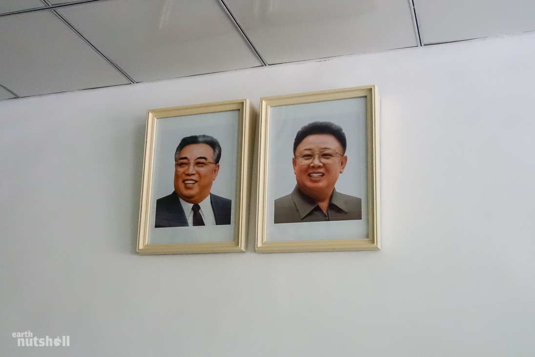
An empty connecting room displays a map of the DMZ and the Korean Peninsula. It’s overlooked by individual photos of Kim Il-Sung and Kim Jong-Il. Note below how the frame is thicker at the top so that the leaders are always looking down upon you.
This is a requirement by law.
As we wait, it suddenly dawns on me – could I get cell phone signal here? We are right on the border…surely South Korean tower coverage reaches. My iPhone has been on flight mode since boarding the plane in China to Pyongyang because well…as we know, North Korea is a communication black spot. Sure enough, disabling flight mode showed two-bar signal to a South Korean cell carrier and I instantly received an automated roaming SMS and one I was sent days earlier.
Awesome.
…And very illegal under DPRK law. After some fleeting feelings of ultimate badass-itry, I set it back to flight mode before I get carted away for either using ROK goods or a ‘GPS Device’.
Entering the DMZ
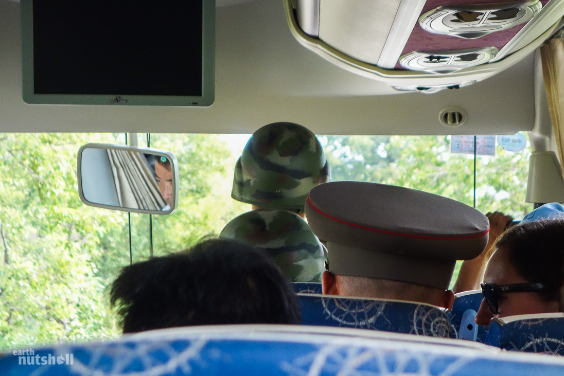
Alright, bus searched and cleared of nefarious goods; we are lined up and walked single file through the gate into the DMZ itself. The bus follows and we re-board with a Korean People’s Army (KPA) colonel and two KPA soldiers to accompany us towards the JSA.
We are getting into the real deal now!
The path we take is set below ground level, built up on both sides by brick. Atop sits huge bulk blocks of stone and the gaps between are filled in by barbed wire and electric fencing. Behind it on both sides? Lush long green grass where nature has reclaimed land, devoid of anything. Not even any crops.
That’s because it’s a minefield.
We sit sandwiched between two desolate fields that form just a small section of the approximate 3 million landmines present across the entire DMZ. Oh and those stone blocks? Those are tank traps, our guides acknowledge them to be rigged with explosives, existing to prevent military pressure bypassing the fields and streamlining through this paved gateway into North Korea.
Lovely.
Mighty Korea respects no minefield however. Solutions are easily devised under their unprecedented technological advancement. The result are four known tunnels underneath as invasion paths into the South Korea. As you’d expect, they have since been locked down. From the South on a DMZ tour they even take you into one. From the North? Their existence is not acknowledged.
There’s even a chance not all have been discovered. Which I find an amazing concept; that there could still be hidden tunnels facilitating people in and out of the country as I type. It’s unlikely though!
Reaching Panmunjom
Halfway into the DMZ, we make a stop. This is the actual location of the late Panmunjom village – there is now nothing left.
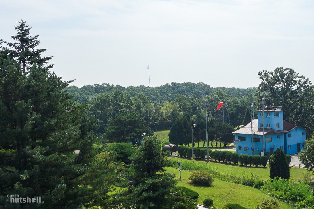
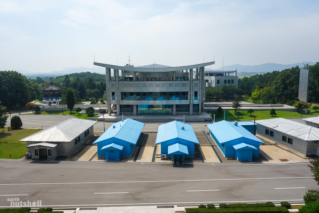
A single military outpost has been erected, pruned gardens line the entrance and two buildings sit within the vicinity. One being the Negotiation Hall where peace talks were held during the war (the original table exists here) – and the other, the (now) North Korean Peace Museum which is where the Korean Armistice Agreement was actually finally signed and history was made. We’re told it was built overnight by the great Workers Party of Korea for the sole reason of facilitating the signing.
Something interesting to note in the image above – see the giant North Korean flag towering in the centre? This is sitting in one of only two villages agreed to remain within the DMZ – Kijongdong in the DPRK and Daeseong-dong in the ROK. In the 80’s, South Korea built a 100 metre flagpole on their side, North Korea took it as intimidation and upped the ante themselves, countering it by building the one pictured – much larger at 160m and almost the biggest in the world at the time.
A flagpole war. Much more peaceful.
Eh, unfortunately North Korea also used that village right up until recently to blast propaganda at the South 20 hours a day, droning away to bored officers to jump the border and come enjoy heaven and luxury in the North. Not joking. Unsurprisingly it had little effect. It’s been proven that the lights in this village are on timers to give the illusion of activity. It’s now dubbed as ‘Propaganda Village’ from the South.
Below is the aforementioned ROK flag sitting in the DMZ bound town of Daeseong-dong across the border:
Negotiation Hall at Panmunjom
We first checked out the negotiation hall. On the outside, a sign denotes when Kim Jong-Il first visited this location. This is more of a prelude to the museum than anything – inside contains just the original table, 10 white veiled chairs for negotiators, and another two smaller offset tables for officials and that’s it, nothing riveting but historically relevant. It was built for this purpose only, and it remains.
I can’t look past the irony of the DPRK going this far in preserving the history and integrity surrounding the Armistice agreement. It’s been six times now they have announced they are no longer going to abide by it – even as recent as 2013. Ah, politics.
But anyway. It’s quite clear this little checkpoint is used as a propaganda machine, a celebration in the ‘victory’ of the North Korean people over the ‘imperialist’ Americans. This becomes clearer at the museum next.
North Korea Peace Museum at Panmunjom
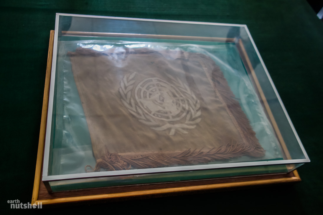
The North Korea Peace Museum is one room containing three tables. The guides stress they are the originals, still exactly as left since 1953 – with the addition of the armistice agreements and ‘original’ flags within glass casings of course. A funny observation I couldn’t help but make is that the original encased UN flag looked to have seen better days – a little worse for wear after this long. Meanwhile, the North Korean flag on the other table was an absolute cracker. It looks brand spanking new. Not even a fade in colour. It must be the superior materials that go into the local product, I reckon!
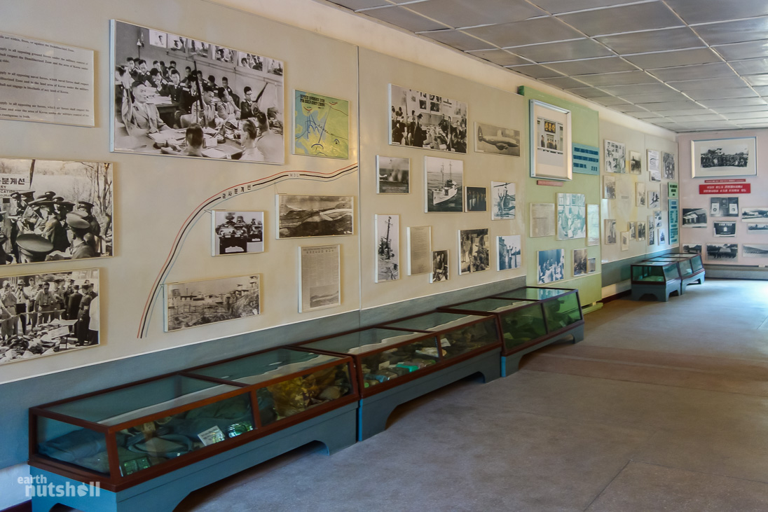
Walls were lined with photography. Most were given context with Korean captions I unfortunately couldn’t read. But it was chronological. A celebration in the war victory of the Korean people leading up to the DMZ and beyond.
Objective isn’t a word I’d use to describe the museum, not that I expected otherwise. Americans are shown with their hands up in surrender, there is ‘evidence’ of American aggression and spy activities, Korean People’s Army training and in battle defiantly, civilian celebration and endearment to the cause and of course Kim Il-Sung spreading his political wings shaking hands, signing documents and leading the party to victory and the armistice finale. Kim Jong-Il is also shown visiting in bright colour photography. This moment is recorded by date and time and presented with pride.
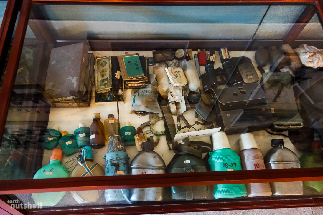
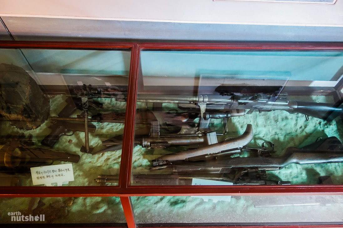
Exhibits of physical items (or evidence as the guides describe it) below were filled with American and ROK war materials.
They even showcased the axe used in the infamous ‘axe murdering incident’ in the JSA where two Americans were hacked and slaughtered with it by KPA soldiers for cutting down a tree in line with a military outpost in 1976.
South Korean ‘puppets’ are slandered. China isn’t mentioned. The North Korean tunnels under the DMZ evade acknowledgement, yet the elusive unicorn of the ‘Concrete Wall’ allegedly built by the Americans is mapped perfectly.
If that wasn’t one-sided enough, a stone monument just outside the front door of the museum reads the following:
The American imperialists, who broke out (provoked) the war in Chosun (Korea) on the 25th June 1950, surrendered on their knees in front of all the heroic North Koreans and signed here the armistice on the 27th July 1953.
Interesting.
Entering the JSA
Another 500 metres or so and we were at the JSA. But not before the bus almost broke down on the slight incline preceding it. These North Korean drivers certainly don’t have much respect for manual transmission.
We are dropped off behind the Panmungak Hall.
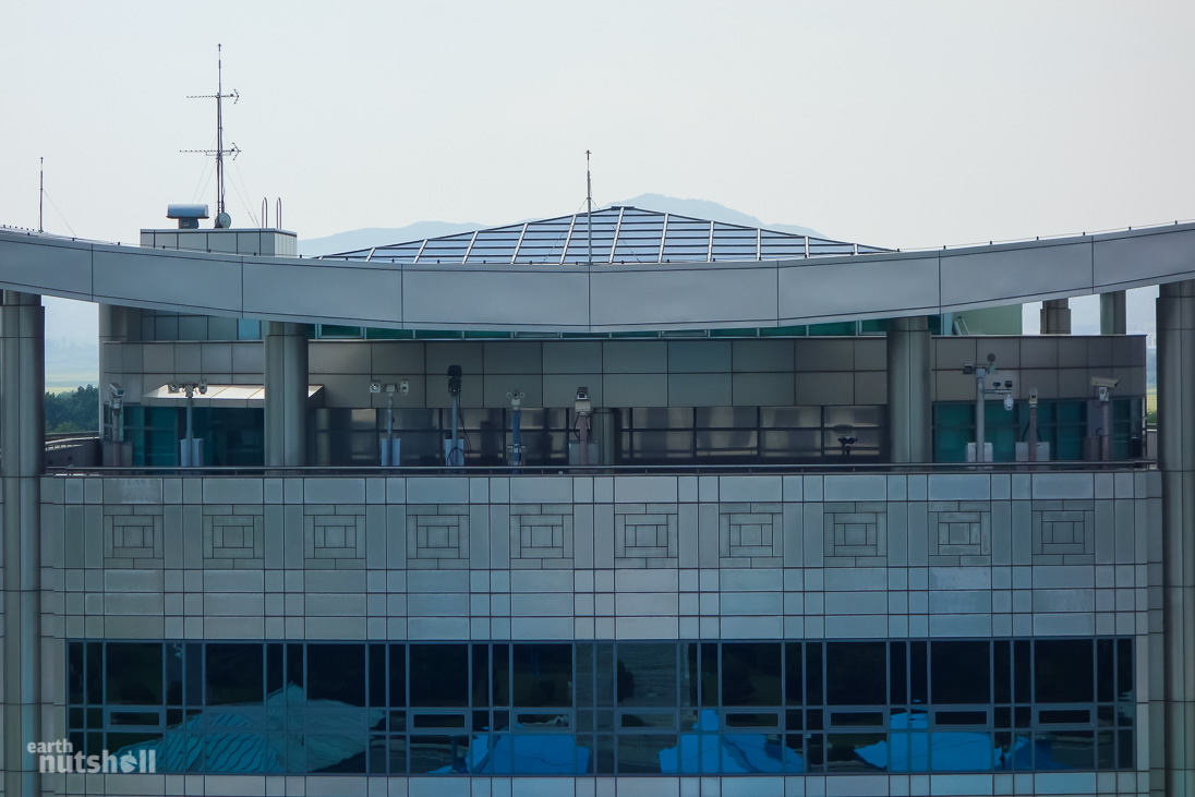
This is the large white building that faces you if you were visiting the JSA from the South Korean side. Both ROK and American guides previously enjoyed toying with tourists by telling them this building was a farce – a fake front, like a movie prop; because from your vantage point in ROK you can’t see whether the building has any depth.
…If there was any doubt, I can confirm a brick and mortar establishment!
Upon disembarking we are instructed to again walk single file. It’s very organised and official.
First impression: It’s incredibly peaceful and relaxed here. Serene really. It’s silent, and their best landscapers have clearly left their mark as it’s now a beautified tourist landing pad. You wouldn’t even have an inkling of the surrounding danger unless you knew prior.
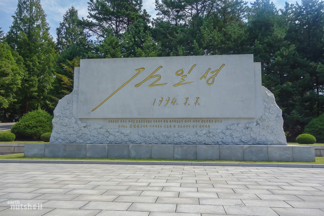
A scripted walk followed onwards to an adjacent stone monument.
From the guides mannerisms, this was clearly a very important monument. No kidding. We discover it’s a memorial to The Great Leader himself; Kim Il-Sung. Etched into the stone in bright gold is his last autograph taken from his final endorsed document on the 7th of July, 1994. Apparently it’s an analysed direct replica. Neat writer, it’s scaled well to this size. The document? It was a proposed one ‘country-two systems’ reunification proposal…of course.
He died the following day though unfortunately.
Other than this; discounting the stock photos inside rooms of the Panmungak Hall (par for the course), shockingly there was no other Kim family propaganda at the DMZ. This was really unexpected.
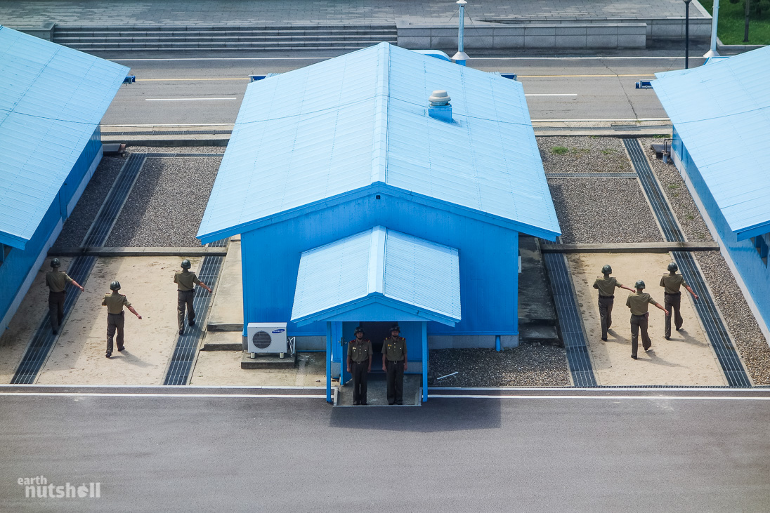
Led by the KPA Colonel, we shuffle through the Punmangak Hall and out into the main area of the JSA.
The border is where the light gravel turns dark, denoted by a concrete line – cross that line, you’ll be shot.
A soviet tourist during the Cold War tried it in 1984 ending in four casualties. So it’s not recommended.
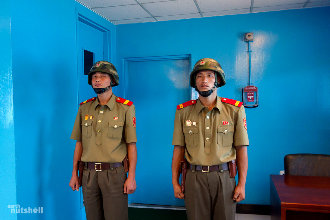
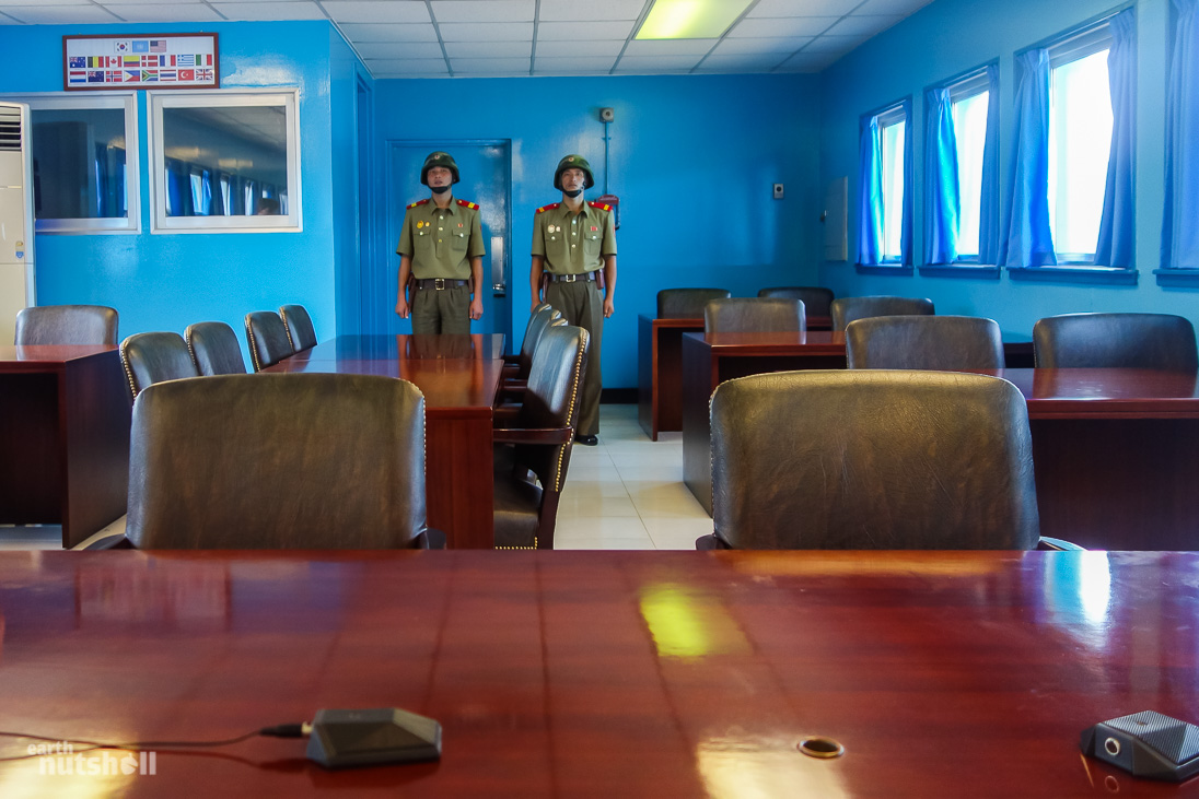
North Korean soldiers are awaiting us. Two precede us in entering the bright United Nations blue conference room. They each take up position at the end of the room guarding a single door. Like statues. Akin to the Queen’s Guard in England. They are within arms reach of a pull alarm.
The door they are to guard? This is a door to South Korea, literally. Like the door to Narnia, except real.
Just one door knob and a hail of gunfire away from a new life.
The conference rooms are infamous – they’re synonymous with the DMZ in pop culture of not only South Korea but globally. They hold novelty value to tourists whilst providing such an important step in reunification. They straddle the Military Demarcation Line (MDL) – half in North Korea, half in South Korea.
The JSA is the only area in North Korea one may peacefully and theoretically “cross” the border into the South – cool right?
Well, sort of. There’s a slight caveat – crossing the MDL can only be done within the constraints of these blue conference rooms. The two sternly looking KPA blokes are technically standing in South Korea in that photo, shielded from the political storm by just four walls and a roof! Freedom is short lived…you can’t even tell whether the air is fresher over that side.
For those that visit the DMZ from the South Korean side, yes these are the same rooms where you can ‘walk into North Korea’. South Korean soldiers will guard the opposite door to North Korea so you aren’t tempted to illegally immigrate into Kim Il-Sung’s haven of freedom…
These rooms do have a proper purpose though, providing a relatively peaceful platform for face-to-face political negotiations between both Koreas. Prisoner exchanges have also been known to occur here.
Seated like an international delegate, the Colonel gave us a similar explanation of their purpose, and how they came to be. Still without mention of China’s role in saving North Korea’s bacon, establishing the DMZ and ensuring continued communist rule in the North.
It’s alright, I’m sure he just forgot. We all make mistakes sometimes.
The South Korean side of the JSA was empty. No ROK or American military nor any tour groups. In fact I saw no movement at all on that side of the border.
This was a shame, it would have been nice to see the face-off if not just for photos. I mean…a couple metres between opposing soldiers each day – do they want to strangle each other? Do they talk to each other? Are they friends? A game of football with a very strict offside? Doubt it. Today I’d get no confirmation though.
What I do know is that the imperialist Americans and puppet South Koreans weren’t in fact off enjoying capitalism in a screening of the new Transformers movie this weekend – South Korea actually ‘closes’ the DMZ on Sunday and Monday for tours. These are also coincidently the only days a visit from the North is possible. It seems to be a recent policy. Is it an odd timeshare arrangement or a way to prevent opposing tour group confrontation? Waving and pointing sounds pretty dangerous after all.
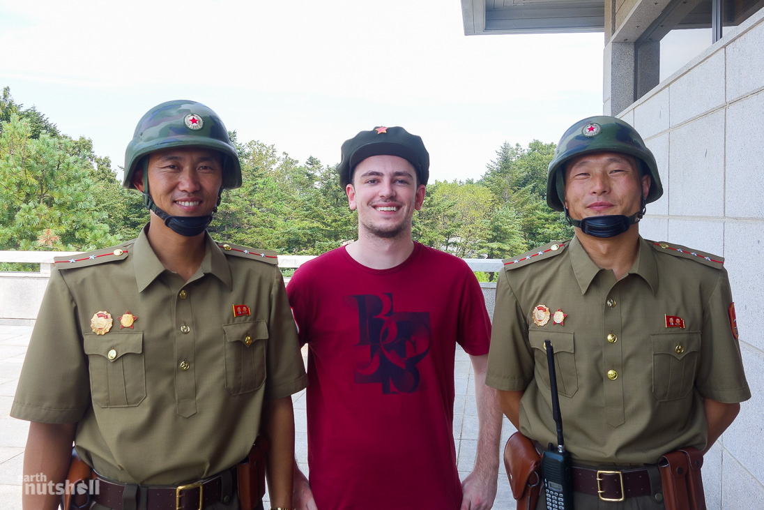
After being flushed from the room by an intimidating dual formation of KPA (to some Korean words which I’m sure were lovely!), we now had the opportunity to go camera crazy from the Punmangak Hall.
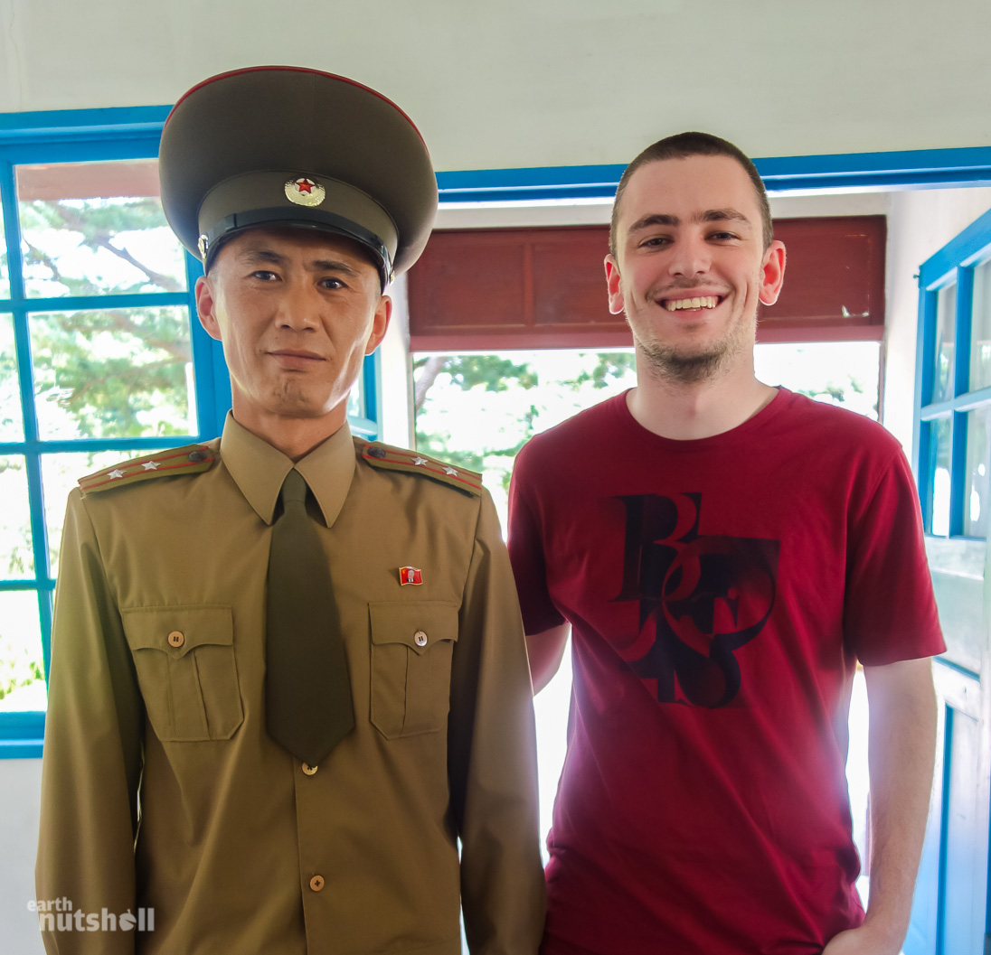
We could also interact with the soldiers whom were more than willing to oblige, even sporting smiles on their faces.
Smiling. In North Korea. Is that even a thing?
It’s a bit odd. The entire JSA experience from the North is much more relaxed than I envisioned. Call me ignorant, but I honestly expected serious faces and five quick controlled minutes watched by on-edge Koreans yelling and shaking their arms every time I made a reach for my camera.
Does it look like that to you?
Quite the contradiction to visiting from the South. North Korea is the scary, mysterious and volatile boogeyman played up for the tourists on the ROK side of the DMZ.
On a trip from the South:
Dress code applies! Don’t point here, don’t wave there. No laughing. Serious faces only. Don’t provoke the North Koreans! Please sign this waver as you’re heading into a volatile area. We can only stay for 5 minutes, it’s too dangerous otherwise! You better have your cameras ready and for the love of god – please don’t take photos of that! Taking photos there breaches national security you know?
Hmm…
Meanwhile…on a trip from the North Korean side: No dress code, relative freedom to take all the photos, go selfie crazy if you like, hell, take some photos with military. Wave, point, make hand signals; the lot. Laugh, even. Anything goes as long as you don’t cross that damn line.
Great stuff – stereotype reinforcement from the South, and the North doing everything it can to troll you into a false sense of security and freedom. North Korea is so much better, right?
My take? This is almost certainly on purpose, possibly a passive aggressive attempt in making a mockery of the precautions on the South. This is the only interaction of this kind I had in the North.
If there’s one thing this country has mastered, it’s how to fool your perception.
As the JSA is central to the DMZ, it truly is an eerily peaceful smokescreen to the ongoing hostility. Each side provokes one another using their gardening skills on well kept lawns and plants. It’s like a little competition on who can manicure the biggest hedge. To quell some JSA misconceptions: There are no guard towers. There is no barbed wire or electric fencing. There is no active servicemen brandishing AK47’s, and there are no visible Soviet tanks, military choppers or anti-air installations, nor sharks with laser beams on their heads. It’s labelled the ‘Truce Village’ for a reason!
Those are set back in the DMZ spread 250km across the peninsula.
What there is though, are surveillance cameras. Lots of them.
Many face us from the ironically named ‘Freedom House’ in the South. Nothing speaks freedom more than a bunch of surveillance cameras. Thanks America! Just perfect.
So that’s the JSA, folks!
And well, that wraps up my time and your tour here of the Demilitarized Zone from the North Korean side. What a fantastic morning it was. We got the tap on the shoulder and it was time to say goodbye, waving to soldiers smiling as if departing a family thanksgiving lunch. Thanks for coming.
Speaking of which, it’s only 12:30pm – lunch was next in Kaesong and in true North Korean style we have a whole day to fill ahead of us. They run us knackered so we’ll be too tired to even consider defecting from our hotel!
I was hungry.
But, not dog-meat-soup-hungry. Sigh, North Korea.
I passed!

P.S – Thanks for reading! It’s long, I know. If you enjoyed it, make sure to share with the buttons below! I’ll be releasing more North Korea content in the near future. Follow on Facebook or Twitter to stay up to date!
For a deeper look into my trip of North Korea, don’t miss my 100 photo montage here: http://www.earthnutshell.com/100-photos-from-north-korea-part1/
P.P.S – Have any of you travelled to the DMZ yourselves, from either the North or South? How did your experience differ? I’d love to hear about it in the comments. Cheers guys, Elliott.
Interested in North Korea? More coming soon! Follow me on Facebook!
The post The World’s Most Dangerous Border – A Tour of North Korea’s DMZ appeared first on Earth Nutshell.